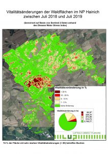
the extreme heat and drought year of 2018 brought a completely new and unexpected dimension of stress for the ecology and management of forests. This led to large-scale weakening and partial death of forest stands, particularly of the spruce tree species, followed by an enormous increase in insect populations. This development continued in the following years 2019 and 2020. The need for large-scale, yet detailed information on forest condition and the short-term development of forest condition grew to unprecedented levels.
The LUP has developed a method that allows a quick and nationwide overview of changes in forest condition, including forest damage, to be obtained from the data available free of charge from the European Sentinel 2 satellite. By selecting the most suitable channel combination from the satellite data and calculating the most meaningful vegetation indices, it is possible to record not only large-scale changes in stand structure (such as storm damage), but also stress symptoms on trees and stands (chlorosis and necrosis on leaf organs; leaf loss in stands) with proven reliability.
More detailed description of the project in the download.
The data is now available for all federal states as at 2023. An annual repetition is planned.
The following parameters were used to mask the results: Forest mask (DLR LandCover-DE 2015). The analyses are based on the percentage comparison of monthly composites (median 01 June to 31 August, cloud mask: CloudProbability < 15%). In almost all cases, the reference year for the comparison is 2017 (except for Saxony and Thuringia, where it is 2018).
The data is made available nationwide free of charge via the >forestwatch< portal.


